By Andrew J. Nelson
WORLD-HERALD STAFF WRITER
HAMBURG, Iowa — Want to go to a Chiefs game this fall? Thinking of Christmas shopping at the Country Club Plaza? You might need an alternate route.
Whether Interstate 29 will get you to Kansas City by then might well depend on a pair of bridges over a stream called Drainage Ditch 6, about a mile north of the Missouri border.
The problem originates several miles upstream, where water pours through a 385-yard breach in the Missouri River levee at Percival, Iowa, passes beneath the Interstate through several pipes and box culverts, then rushes south, eventually running up against the backup levee that still protects Hamburg.
The only place for the water to go is back under I-29 — through Drainage Ditch 6, Iowa state roads officials said during a World-Herald tour of the closed Interstate this week.
"It's all coming here and coming out through this little ditch," said Jim Bane, district maintenance manager of the Iowa Department of Transportation. "It has undermined the road on which we're standing. It just hasn't collapsed."
A hole formed on the southeast corner of the northbound I-29 bridge over the ditch, a hole so large it took transportation workers 30 to 40 dump trucks of rock to fill it.
A similar, less problematic hole formed on the southbound bridge.
The crossing is the most at-risk spot on I-29 "that we know of," Bane said. "We could have other places on this system where it has undermined."
Roads officials won't know for sure until more of the water drains away.
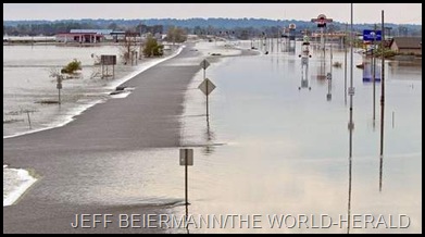
This week, The World-Herald toured flood-closed parts of I-29 from Pacific Junction to the Missouri border.
The tour revealed an Interstate largely OK on the surface.
Reopening the roadway in some places could be as simple as removing construction barriers and debris.
Most, if not all, of I-29 could be opened by the end of the year, Bane said.
That contrasts with Interstate 680 near Crescent, where flooding washed away much of the roadway.
"Overall, I-29 — when you compare it to I-680 ... is in pretty good shape," he said
But the vastness of the blue-brown water surrounding I-29 could mask damage visible only after the waters recede.
The problem at Drainage Ditch 6 is this: If both bridges require a substantial fix, drivers will have no path to get past. And many potential detour routes could be damaged.
"It could be that there are no exits between Glenwood and somewhere in Missouri," Bane said.
Driving south on I-29 near Pacific Junction, everything seems normal at first — except that there are no other cars.
Into Fremont County, Iowa, water surrounds white-framed Bartlett Community Church, making the town look like a Grant Wood version of Venice. Bane said there may be no need there for a roadway inspection.
But that changes north of Percival, where the waters from the levee break once rushed over the Interstate but now flow beneath it.
A big cause for concern is erosion around the culverts and pipes from water rushing through. Just inside the flooded fields to the west, brown water swirls in whirlpools — some look big enough to pull down a man.
"That swirling action, just like you see in the bathtub, will suck any soil that it comes up against," Bane said. "That's what has me concerned about these pipes and these box culverts."
At the Percival exit, water pushes through a pipe or culvert at a natural low spot where water rushed over the road after the breach.
"I'm going to expect to find we've got some kind of void," he said of the spot. "With it coming through that hard, it just makes it much more likely there's a problem."
Tree branches, cornstalks and other debris become more prevalent south of Percival. Near the Iowa Highway 2 exit to Nebraska City, two fuel tanks stick out of the water to the west. A refrigerator and a toilet seat sit by the side of the road.
The interchange at Highway 2 is like the scene of an aquatic disaster movie. Water surrounds the Americas Best Value Inn and the Sapp Bros. Travel Center. Highway 2 acts as a dam — much as I-680 did — with the water on its north side visibly higher than on the south.
"I expect it to look just like 680. It's actually had water running on it longer," Bane said.
Some water is being channeled into a 15-foot-deep trench that runs under I-29 and into a field to the east.
"It's undermined the footing that is part of the supports of the bridge (that holds up the Interstate)," Bane said.
No early cost estimate for likely I-29 repairs is available, but Bane said it could be in the tens of millions.
Asked what the public should know about the road repairs, Bane said transportation officials will get the highways open as fast as possible.
"We want them to understand, as best as they can, it's just a mess," Bane said. "It's going to be messed up a lot longer than we want it to be."
Contact the writer:
402-444-1310, andrew.nelson@owh.com


No comments:
Post a Comment